All articles - physical geography
-
 Toponyms (place names) represent language units denoting elements of topographic environment. The relevance of the study is caused by the need to develop the theory of toponymy and to systematize all the existing toponymic classifications. Place names have a complicated (multidimensional) nature, which should be taken into account while classifying them
 -
 This article provides information on the technique of running short distances.
 -
 This article shows various options for selecting and forming crews by analyzing the foreign experience of forming team crews in academic rowing sports. It was determined that the system of selecting and training crews in each country has, on the one hand, general and, on the other hand, specific national characteristics.
 -
 DEVELOPMENT OF SPORTS AND HEALTH TOURISM: PROBLEMS AND WAYS TO SOLUTION.This article analyzes the insufficient development of sports and health tourism in Uzbekistan, and also determines the role and importance of a manager in its development.
Modern Science and Research -
 The relevance of research on the adaptation of young physical education teachers is dictated by the modern challenges of Russian education, primarily the need to meet the targets of the national project "Education", in particular, "70% of teachers under the age of 35 will be involved in various forms of support and support in the first three years of work, by the end of 2024." Young teachers, including physical education teachers, in the conditions of the new geopolitical reality are the strategic resource that should become the main one in the formation of a new paradigm of education in Uzbekistan. The aim of the study is to assess the adaptation process of young physical education teachers in Yekaterinburg, to identify the main reasons for the difficulty of entering the profession and moving to the next stage of professional development. The article was written on the basis of the study conducted by the authors in May 2023. research of young teachers – teachers of physical culture, whose experience does not exceed five years. In total, 20 teachers of Yekaterinburg schools were interviewed. Socio-professional adaptation is understood as "the process of interaction between the individual and the professional environment, during which the development of goals, values, norms of professional activity is carried out, due to a combination of external and internal factors that ensure the optimal functioning and development of the individual in the profession."
 -
 This article contains information about table tennis and its positive and effective sights, it’s two types with information about them. Tennis, original name lawn tennis, game in which two opposing players (singles) or pairs of players (doubles) use tautly strung rackets to hit a ball of specified size, weight, and bounce over a net on a rectangular court. Points are awarded to a player or team whenever the opponent fails to correctly return the ball within the prescribed dimensions of the court.
 -
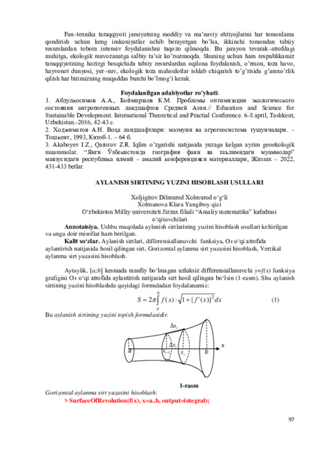 Ushbu maqolada aylanish sirtlarining yuzini hisoblash usullari keltirilgan va unga doir misollar ham berilgan.
 -
 Xiva hududi geologik va gidrogeologik sh aroitini seysmik xavf nuqtai nazaridan o‘rgani shMaqolada Xivaning geologik va gidrogeologik sharoitlarini o'rganish bo'yicha olib borilgan instrumental kuzatuvlar natijalari bo'lajak zilzilalar paytida mintaqa intensivligining o'sishini baholash uchun taqdim etilgan.
Новый Узбекистан: наука, образование и инновации -
 Surxondaryo viloyatidagi relyef bilan bog‘liq joy nomlariUshbu tezisda Surxondaryo viloyatidagi kelib chiqishiga ko'ra relyef bilan bog'liq joy nomlari haqida batafsil ma'lumot berilgan. Unda biz Surxondaryo viloyatining joy nomlari xususiyatlari, shakllanishi, hozirgi holati haqida ma’lumotlarni bilib olishimiz mumkin. Viloyatda ko'plab joy nomlari relyef bilan bevosita bog'liq ekaniga guvoh bo'lasiz.
Sustainability and science: new research for new solutions -
Subject of research: slopes with various inclinations from loess soils characterized by different physical and mechanical measures.
Purpose of work: to work out the method of seismic stable slope that would assess the dynamic stability of slopes and measures that provide seismic stability of slopes under dynamic (seismic) influence.
Method of research: laboratory experimental researches on the models of loess slopes using modem measuring instruments and techniques.
The results obtained and their novelty: the dynamics of stable and dcfonnational functions of the loess in slopes of different profile was studied depending on the content and condition of soils under the seismic influence of different intensively; the calculation method of determining the critical acceleration is proposed for inclined surface of soil thickness (criteria of soil structure's dynamic stability); the condition of diluted zone’s appearing out of steep slope and the size of dynamic loading was displayed; “the method of seismic stable slope” fro evaluation of slope’s dynamic stability is proposed herewith; the measures for providing the seismic stability of slopes by loading the surface of the slope were worked out.
Practical value: consists of working out the criteria for evaluation the possibility of landslides dilution, method of slope’s seismic stability and measures which provide the seismic stability of dewy slopes.
Degree of embed and economic effcctivity : the results of the research were used the evaluation of seismic stability of the erection built on natural slope. The summary of dissertation paper is used by MA students of TASI specializing in “Hydro technical erections” as scientific example. The economic affcctivity of seismic stable slope and ways of loading the slope is first of all aimed in providing the seismic stability of loess slope.
Field of application: to provide seismic stability of dewy loess slopes in seismic regions. -
 Марказий Осиё сейсмик фаол ҳудудларидаги ер ости сувларида гелий намоён бўлишининг ўзига хос ҳусусиятлари
Catalog of abstractsТадқиқот объектлари: Марказий Осиёнинг сейсмик фаол сриклар зоналари.
Ишнинг мақсади: Марказий Осиё срости сувларида гслийнинг тақсимланиши хусусиятларини ва уни зилзилаларни прогноз қилишда қўллаш имкониятини аниклаш.
Тадқиқот методлари: Барча вазифалар гелийнинг срости сувларидаги мутлақ микдорини мажмуали тахлил этишнинг муаллиф томонидан ишлаб чиқилган усули асосида счилган. Гелий микдорини ўзгариши қонуниятларини ва табиатини аниқлаш, ҳамда зилзилаларни прогноз қилишда инструментал-аналитик усуллар кўлланилган.
Олинган натижалар ва уларнинг янгилиги: Биринчи маротаба Марказий Осиёнинг геологик-тектоник шароитлари учун срости сувларида гелийнинг эркин микдорини аниқлаш усули ишлаб чиқилган. Регионнинг турли гидрогеологик шароитлари учун алоҳида геодинамик полигонларда гелийнинг мутлақ микдори ўрганилган. Геологик-гидрологик майдонларда гелий аномалияларининг фазо-макондаги конуниятлари сейсмопрогноз мониторингни ташкил этиш ва уларни табиий генезисини баҳолаш учун гелийнинг вариациялари асосида ажратилган. Гслийнинг срости сувларида тарқалишининг хусусиятлари ўрганилган ва уларнинг юкори микдори узилишли бузилишлар зоналари ва блоклар чсгараларида кузатилиши аникланган. Ушбу худудлар учун биринчи марта гелийнинг срости сувларидаги микдори аномалиялари ва уларни зилзилаларни тайёрланиш парамстрлари билан богликлиги коррсляцион боғлиқликлар бўйича баҳоланган.
Амалий ахамияти: Гелийнинг срости сувларидаги микдорини ўрганиш бўйича муаллиф томонидан ишлаб чиқилган усул зилзилаларни прогноз қилишда сейсмопрогноз кузатувларни сифатини сезиларли оширади.
lyruiri vvri 11 v j i\j jui j ujiu|jiiii vrivjyui iiiiii vvjMJiuy;in vluii
Татбиқ этиш даражаси ва иқтисодий самарадорлиги: Ишлаб чиқилган усул Узбскистоннинг барча гео динамик полигонларидаги рсжимли кузатувлар амалиётига тадбиқ этилган ва Озарбайжон, Қирғизстон, Арманистон, Туркманистондаги турдош ташкилотларда қўлланилади. Улар шунингдек УзР ФА Сейсмология институтининг хафталик Прогноз комиссияси маълумотларида қўлланилиб, унинг натижалари ва хулосалари Узбекистан Рсспубликаси Фавқулодда вазиятлар вазирлигига юборилади.
Қўлланиш (фойдаланиш) сохаси: Геофизика, сейсмология, зилзилаларни прогноз қилиш, келгусидаги зилзилалар зоналарини аниклаш. -
 Research of the strength of soils, stability and effectiveness of anti-landslide activities in the mountain and foothill areas of Uzbekistan
Catalog of abstractsSubjects of research: slopes, natural slopes, landslide, state of stress strain, model of soil, Method of fined elements, retaining wall, efficiency, constructive solution.
The purpose of work: to study a state of the stress strain of slopes and slopes from the application of elastic-plastic models, eating, and the identification of optimal solutions of the constructive anti-landslide facilities.
Methods of research: based on the use of modem scientific positions of soil mechanics, foundation engineering and modeling theory, carrying out complex experiments in the laboratory and in situ, numerical modeling of clasticplastic models, finite element and simplex methods calculation.
The results obtained and their novelty: On the basis of laboratory and in situ experimental studies of regional soils, obtained basic qualitative regularities and quantitatively the results of deformation and strength. We propose a soil model, which describes the actual behavior of the vertical slopes of stress-strain state. And on the basis of these analytical and numerical calculations using the clastic-plastic models revealed the most rational solution of retaining walls.
Practical value: is the possibility of using the results obtained in the calculation a state of the stress strain and determining the degree of stability of slopes and slopes with complex geometric configurations. Recommended computed model soil allows determine more accurately of stress-strain state rate and pressure of the landslide slope stability and slope by numerical methods. Recommended of anti-slide protection activities and retaining walls for the effectiveness use.
Degree of embed and economic affectivity: a project for strengthening the slope on the Akhunbabaev street and angle retaining wall on the Shahi Zinda street necropolis in Samarkand sity, a program of "Calculation of natural slope stability, taking into account the variable humidity of loess soils".
Field of application: Design and construction. -
Objects of research: an earth's crust of the Surkhandarya depression.
Aim of the inquiry : studying of a deep geological structure of the Surkhandarya depression, mapping the deep borders of the earth's crust, surface of the basement and its display in a modem relief.
Method of inquiry: the complex analysis of the geology-geophysical data, first of all seismic survey materials of method of exchange waves of the earthquakes, results of gravitation prospecting, deep drilling, with attraction information on allied industries.
The results achieved and their novelty: by data of method of exchange waves of the earthquakes were allocated the body area identified with mantle plum which breaks through Moho surface, in the southern and western part of researched territory in the bottom part of the earth's crust - Moho intermediate zone, which presence proved by results of geodensitive modeling. Were mapped the Surkhandarya fault. It is established that the researched area has entered in active orogenic phase of development in the end of Pliocene and in the beginning of Quaternary period.
Practical value: were constructed the schematic map of the surface of buried relief of the basement by the data of method of exchange waves of the earthquakes. On the basis of the analysis of the bedding features of the Paleozoic basement disjunctive dislocations arc revealed and were made the estimation of a degree of dislocation of Paleozoic deposits that has allowed revealing sites for statement in the future for purposeful exploration.
Degree of embed and economic affectivity: given recommendations on carrying out of additional field researches, improvement of profile VI-VI with the purpose of specification of a deep structure of east zone of the Surkhandarya depression and also the recommendation on revealing local oil-gas-bcaring structures which have been accepted in Open Society "Uzbekgeofizika".
Field of application: oil-and-gas branch of Republic Uzbekistan, the exploration enterprises which arc carrying out search and prospecting of oil and gas accumulations. -
Subjects of the inquiry: holoccnc sediments in the basin Chirchik.
Aim of the inquiry: To establish the characteristics of spatial-temporal structure of the geomagnetic field through the holoccnc palcomagnctic study of sections of the river basin Chirchik and drafting magnetostratigraphy scheme of Holoccnc sediments in the region
Methods of inquiry: magnetostratigraphy holoccnc on the basis of integrated field and laboratory palcomagnctic studies.
The results achieved and their novelty: For the first time the continental deposits of the holoccnc basin Chirchik by magnetostratigraphy studies modeled the structure of the geomagnetic field of the Holocene, the scheme magnetostratigraphy subdivision and correlation of the studied sections and the correlation magnetostratigraphy scheme. Age characteristics of short-term deviations of the holocene dates the gcomorphological levels of terraces and use them for palcogcographic reconstruction of extensive regional coverage and linkage with paleoclimatic and archaeological data.
Practical value: Established stratigraphic levels of short-term geomagnetic events of the holocene, which determine the palacomagnctic reference frame for the studied sediments and allows their use magnetostratigraphy dismemberment of holocene sediments for geological and stratigraphic problems, the implementation of the correlation, the development of the regional stratigraphic scheme of continental holocene formations on the territory of Uzbekistan.
Degree of embed and economic effectivity: The results of the study in the State Committee of Uzbekistan on Geology and Mineral Resources and the learning process of the geological department NUU named after Mirzo Ulugbek implemented. Studies have considerably strengthened the stratigraphic base of subdivision and correlation of holocene sediments, which ultimately enhances the effectiveness of geological prospecting, geological survey work and research of engineering geology.
Sphere of usage: Quaternary geology, stratigraphy, geomorphology, paleogeography, paleomagnetism, palcoclimatology, archeology. -
Subject of the research: new lands forms in the old place of Aral and territories with the sea deflection in the Eastern part of the sea.
Purpose of work: scientific analyses of dry land wich forms in old place of Aral as an individual natural geographic region.
Methods of research: software of GIS technology programs of “Mapinfo” and “CorelDRAW”, palcogcographycal, historical, cartographical, aero cosmic, divide into districts.
The results obtained and their novelty: sor the first time:
- dry land bottom of Aral given as independent unit as - Aral natural-geographic
area.
- created a map of landscape-typical units and natural-geographic district. Define
33 aspects of landscapes belong 2 kinds, 3 groups, 1 undertype, 1 type and 1 form.
- natural-geographic district look as scientific bases of regional natural-
geographic research.
Practical value: main results of research can use in elaboration for preservation and rational using of natural resources of dry land bottom of Aral, and also helps to reading some courses by natural geography of Central Asia and Karakalpakistan.
Degree of embed and economic effectivity: materials and results of these dissertation now using in study courses of National University of Uzbekistan named by Mirzo Ulugbek, Karakalpak Stat University named by Bcrdakh, in committee of nature preservation of Republic of Karakalpakistan in elaboration measures to rational using of natural resources.
Field of application: in preservation and rational usage of natural resources, in GIS technology and higher educational institutions. -
 Structure and lateral heterogeneity of the Jurassic section of Bukhara-Khiva region supported by the geophysical data
Catalog of abstractsSubject of the research: Jurassic sediments in Bukhara-Khiva region.
Purpose of work: development of the methodology of integrated interpretation of geological and geophysical data, and its application in studying formations, structure and composition of the Jurassic section of Bukhara-Khiva region, including treatment of the new conception of the geological evolution of sedimentary basin, and identification of lateral heterogeneities.
Methods of research: Integrated analysis of geological and geophysical materials, including drilling data, well logging data, seismic data, and also developed methodology of integrated interpretation of geological and geophysical data, including mathematical modeling of seismic wave fields.
The results obtained and their novelty: New scheme of the methodology of integrated interpretation of geological and geophysical data including mathematical modeling of seismic wave fields has been proposed. Cyclostratigraphic and seismic stratigraphic division of the Jurassic section. The history of geological evolution of Bukhara-Khiva region in the Jurassic time has been studied.
Practical value: Developed methodology of integrated interpretation of geological and geophysical data can be applied in detailed study of geological structure of other prospective oil and gas areas with similar geological and tectonic settings. Based on conducted seismic formation analysis and other a priory information, the zones with prospects for finding oil and gas traps have been identified.
Degree of embed and economic effectivity: Developed methodology of integrated interpretation of geological and geophysical data has been introduced in the educational process in the faculty of Geology in the National University of Uzbekistan. The recommendations were given on conducting detailed seismic acquisition works, within discovered prospect areas, aimed at finding traps and pools of hydrocarbons.
Field of application: oil and gas sector of the Republic of Uzbekistan, exploration organizations, and system of education. -
 Genesis, physic-chemical and biogeochemical features of arzyk-shokh, shokh-arzik layers in lands of the central Fergana
Catalog of abstractsThe urgency and relevance of the theme of dissertation. Currently, as a result of degradation of croplands, desertification and water logging, water and wind erosion, salinization and pollution thousands of hectares of lands falling out from agricultural use. «In the world about 40% of irrigated landsarc saline in varying degrees, 7 mln. hectares of lands are exposed to degradation and each year 25 mln. hectares of landschanges to desert»1. As a result of the impact of the anthropogenic factor to the soils, growing degradation under these conditions in the different barriers of geochemical landscapes and evaluation processes of accumulation and differentiation of chemical elements is on a number of topical issues 2'
The study of chemical and geochemical features with pcdogcochcmical standpoint of saline soils with bad water and air permeability is one of the urgent problems of the agricultural practices in irrigated areas of Uzbekistan.
Study of Fe, Ca, Mg, Na, Ba, K, Sr and other macro and micronutrients, toxic metals and metalloids such as antimony, arsenic, cadmium, mercury,low studied and non-studied (Kist) elements: lithium, strontium, cesium, gold, scandium, ytterbium, lanthanum, samarium, tin, uranium, thorium and others in agricultural landscapes in the system of plant-soil-soil forming breeds, as well as in soil, arzyk-shoh, shoh-arzyk horizons, constitute the basis of the relevance of the topic.
In a world considerable scientific and practical importance has study of typomorphic and paragcnctic groups of elements in individual soil samples and soil-forming rocks. Great theoretical and practical importance is the study of migration and accumulation of a number of these elements in irrigated soils, pcdogcochcmical and other soil barriers. Along with the above definition of migration, accumulation of elements and development of background content, soil-gcochcmical barriers, bank of data, etc., in turn, make up the relevance of the topic.
In an open and closed-pcdogeochcmical conditions, in buried soils or pedoliths study of chemical elements and compounds, migration, accumulation, differentiation considered as relevant issues.
Decree of the President of Uzbekistan «On measures to improve ameliorative condition of irrigated lands and rational use of water resources for the period 2013-2017 years» from 19/4/2013 № UP-1958 and adopted on the basis of this decree of the Cabinet of Ministers on 28 November 2008, number 261 Programme of comprehensive measures to improve ameliorative condition of irrigated lands and rational use of water resources identified important challenges for the implementation of the program. Scientific validity and performance of these tasks to a certain extent arc given in the dissertation research.
Purpose of the study. Determination pcdogcochcmical and agrogcochcmical, ameliorative properties, as well as the fertility of irrigated saline, pedolithieal mcadow-saz soils of Central Fergana.
Scientific novelty of the research is in the following:
approximation to the surface arzyk-shoh and shoh-arzyk horizons, towards the center increases and approaches the surface;
defined baseline content of a number of micro- and macro elements in pedolithieal horizons and soils;
advanced features of oxygen and bilateral barriers;
opened molybdenum weak, medium and strong anomalies and defined their respective provinces.
CONCLUSION
Sequential study of the natural flows of chemical elements in soils and pedolithieal horizons, conducted in soil geochemical spectrum on the local and regional level, made it possible to put forward the following scientific positions.
1. Flows of chemical elements and their compounds bind all genetic soil horizons, as well as pedolithieal horizons and elementary landscapes in one geochemical landscape. These flows constitute a comprehensive system of interdependent chemical and biogeochemical cycles of the studied elements.
Proccssesof accumulation, migration, differentiation of chemical elements in soil and pedolithieal horizons and parent material occurs at the joint participation of pcdogenic, exogenic, cndopcdogcnic, man-made factors. These streams of elements in turn affect the nature of the substrate, i.e. soils,pedolithieal and soilforming rocks. In this process, unexplored elements form only scattering flows.
2. Flows of chemical elements in soilsplay a significant role in anthropogenic changing cycle of the elements. Particularly strongly influence localized streams of heavy elements such as Mo, Ba, Sr, and othersto the landscape blocks. This influence is reflected in the reduction of soil fertility and the deterioration of the living conditions of agricultural plants. The nature of migration and transformation of the studied chemical elements in the soil is a determined by the landscape-geochemical conditions and the properties of the elements.
3. The reason for the accelerated restoration of water-soluble salts, after washing pedolithieal soil serve shallow washingof salts, ie from the surface not deep arzyk-shoh, shoh-arzykhorizons in saz meadow soils. When watering wheat on not deep pcdolithicalsoils often shoots die, a cause of the this is watering, which arc held in May and moisten the soil to a depth of pcdolithicalhorizons, ie, to a depth of 18-33 cm, 32-55 cm. After the watering during 2-3 days, sulphate and chloride salts migrate upwards, thus in these soils under salinization by 0.5-1% of dry residue forms a temporary soda,under its influence firstly shoots becomes yellow and then die completely.
4. There is a degradation of arzyk-shoh, shoh-arzyk soil horizons with the growth of the cultural condition of irrigated lands. At the same time there is a gradual, slight destruction of horizons. This is a positive trend. For these horizons with increasing atomic weight and complexity of the nuclei increases Clark content of Na, Mg, K, Ca, Fe, Rb, Sr, Ba, Sc, Cr, Co, Ni, As, Br, Cd, Sb, Cs, Hf, Ta, W , Au, Hg, La, Ce , Nd, Sm, Eu, Tb, Yb, Lu, Th, U et al.
5. The chemical potential in real solutions, such as soil solution is not determined by the concentrations of ions butby their activity.
With increasing concentration of sodium cationsdccreases its' activity. This correlation between concentration of the soil solution and sodium cation is 0.2 ie,is positive, and between average activity and activity coefficient is 0.66,that the relation is good.
6. Arzyk-shoh, shoh-arzyk horizons of irrigated meadow saz soils arc their genetic horizons and called pedolits. These horizons with a of result of a long-term irrigation and the cultivation gradually losethcir basic properties and disintegrate slowly.
7. Close chemical composition and concentration of Clark, accumulation, differentiation in arzyk-shoh 93-111 cm, 32-55 cm and 18-33 cm horizons provide a basis to judge the proximity of the genesis of these horizons.
8. Dissipation and accumulation of the chemical elements in the blocks of elementary landscapes and it’s mirror depend by properties of the elements by thcmselvesalong with the landscape characteristics. In the studied soils with increasing of atomic mass and charge of elements decreases their scattering, thusincreasing their accumulation.
9. The provinces with high the content of the elements the affect the soils of accumulative landscapes, such as irrigated meadow saz soils. Provinces with high content of the elements correspond to of oxidative, gley, evaporativebarriers, also carbonate-plaster, gypsum-carbonate barriers of the studied soils.
According the location from the surface of soil provinces and barriers the can be divided to deep-into (50-100 cm) and dccp-(30-50 cm), surface (0-30 cm). Influence of surface and deep provinces arc not the always reflected in the properties of plants, ie, their impact in turn depends on the penetration depth of the root system of plants.
10. In useful (elevated) provinces and associations content of elements in the soil is high in relation to the background, this situation is positive for a number of plants that arc in need of these items, resulting in increasing of plant productivity.
11. On the areas with negative provinces in the soil there is a shortage of a number of elements for the plant, to meet the needs that contribute the missing minerals.
12. The weak, medium, high elevated molybdenum province is characteristic for sulphate saline irrigated meadow saz soils, where it respectively contains 2-4 CC, 6-10 CC, 10-12 CC.
Lack of molybdenum for cotton plants is detected with an average content of molybdenum in an amount of less than 1.5 mg/kg.
13. For these soils and pedolithieal horizons content of macro elements Na, Mg, K, Ca, Fe, Rb, Sr, Ba, microelements Sc, Cr, Co, Ni, As, Br, Cd, Sb, Cs, Hf, Ta, W, Au, Hg, lanthanides and radioactive elements La, Ce, Nd, Sm, Eu, Tb, Yb, Lu, Th, U et al. is as background content.
14. For Farmers Union, management of agriculture and water resources ofdistricts recommended produce agricultural crops, taking into account the length of the main massof roots of crops and the depth of the pcdolithicalhorizons. It is also recommended for supply of washing standards of water for these soils should be amended taking into account the depth of the pedolithieal horizons.
15. We recommend the use of materials of a dissertation by scientific-research, survey organizations and management of the land cadastre, department of nature protection during monitoring, evaluation and other works background amounts of macro- and microelements. Methods and the results of geochemical province, barriers that arc developed in the thesis, teaching aids used in the Fergana State University and Fergana Polytechnic Institute in teachingcourses of chemistry and biogeochemistry of soils, as well as special courses. -
 Scientific foundations of genesis, agrophysical and agrochemical properties, increasing the productive capacity of the sands of Central Fergana
Catalog of abstractsThe aim of the research work is to increase the productive capacity of the sands of Central Fergana, to improve anti-erosion technologies, and to develop new agrotechnologies for the care of crops.
Scientific novelty of the research worlds as follows:
For the first time, the improvement of agrophysical and agrochemical properties as well as nutritive regime of sand areas with a natural screen as a result of leaving of rye stubble of 14-15 cm height is proved;
The increase in yields of cotton and other crops included in the cotton complex on deflated hilly-barkhan and sandy lands is determined underapplication of effective norms of mineral and organic fertilizers;
The technology of water saving and improvement of the ecological and reclamation state of sandy lands by creation of natural and artificial screens is developed;
It is determined that as a result of creating natural screens in cotton fields of farms, the cotton boll are opened for 3-4 days earlier compared to conventional method;
A technology has been developed for the use of drainage and irrigation ditch deposits through measures aimed at improving the ecological state of the environment. -
 Scientific foundations of genesis, agrophysical and agrochemical properties, increasing the productive capacity of the sands of Central Fergana
Catalog of abstractsThe aim of the research work is to increase the productive capacity of the sands of Central Fergana, to improve anti-erosion technologies, and to develop new agrotcchnologies for the care of crops.
Scientific novelty of the research workis as follows:
For the first time, the improvement of agrophysical and agrochemical properties as well as nutritive regime of sand areas with a natural screen as a result of leaving of rye stubble of 14-15 cm height is proved;
The increase in yields of cotton and other crops included in the cotton complex on deflated hilly-barkhan and sandy lands is determined underapplication of effective norms of mineral and organic fertilizers;
The technology of water saving and improvement of the ecological and reclamation state of sandy lands by creation of natural and artificial screens is developed;
It is determined that as a result of creating natural screens in cotton fields of farms, the cotton boll are opened for 3-4 days earlier compared to conventional method;
A technology has been developed for the use of drainage and irrigation ditch deposits through measures aimed at improving the ecological state of the environment. -
 Economic-geographical features of the location and development of the food industry (In the case of Khorezm region)
Catalog of abstractsThe aim of research work To improve the regional structure of Khorezm region based on the analysis of its socio-economic, environmental factors of food industry as well as to develop proposals and practical recommendations to establish the food industry regional cluster of the republic in the region.
Scientific novelty of the research work are the followings:
effective economic-geographical structure of the process «raw material-processing-ready material» was created to establish food industry regional cluster in the republic;
the characteristics of the territorial structure of the first logistics centers to develop the food industry including internal (manufacture of specific types of fruits and vegetables (karvak) apples, grapes, (gurvak) melons, rice and the glycyrrhiza redix) and external (Khazorasp free economic zone, the transport infrastructure, availability of consumers on the external market) opportunities were proven in economic-geographical respect;
regional factors of food industry of Khorezm region and branches which supply it with raw materials were elucidated and maps were created according to the GIS database;
cluster system of food industry has been improved economically and geographically combining both innovative experiences of developed countries’ approach towards cluster system and regional features; -
 Economic-geographical factors of agricultural development in the areas of desert of southern Uzbekistan
Catalog of abstractsThe aim of research work: Discovering the key factors of agricultural development in the deserts of southern Uzbekistan and elaborating proposals and recommendations on the solution of existing problems.
Scientific novelty of the research work:
From the economic geographical factors of agricultural development in southern Uzbekistan, soil-climatic conditions, the use of agricultural land, water consumption norms, efficiency of property forms, and population aggregate zoning have been determined;
software for optimization of the structure of cultivated lands for the effective use of land and water resources;
the administrative, economic and ecological aspects of the development of hydromeliorative agrarian-industrial cycles in the region;
recommendations for improving the territorial system for organizing the activities of agricultural producers on the basis of strengthening the infrastructure potential of the agricultural sector, effective water resources management, the development of multidisciplinary farms and desert-pasture livestock, and monitoring the reclamation status of irrigated land have been developed.